What defines a major US Interstate?
Major US Interstates are part of a nationwide network of freeways connecting principal cities and regions across the United States. These limited-access highways are characterized by their distinctive shield-shaped markers, often with a red, white, and blue design. They are designed for high-speed, long-distance travel, facilitating efficient movement of people and goods without at-grade intersections, offering a consistent travel experience across state lines.
How do I find an Interstate on Google Maps?
To find an Interstate on Google Maps, open the app and use the search bar to enter the Interstate number, for example, 'I-95' or 'Interstate 70'. The map will display the route and allow you to get directions, view traffic conditions, and explore nearby services. You can also simply input your destination, and Google Maps will typically provide a route utilizing the most efficient Interstates available.
Are paper US Interstate maps still useful in 2026?
Yes, paper US Interstate maps remain highly useful in 2026, especially for comprehensive trip planning and as a reliable backup to digital navigation. They offer a broad, distraction-free overview of the entire system, which is excellent for visualizing long routes and alternate paths. In areas with limited or no cellular service, a physical map becomes an indispensable tool for maintaining your sense of direction and ensuring continuous navigation.
What are the longest US Interstates?
The longest US Interstates include I-90, stretching over 3,000 miles from Seattle, Washington, to Boston, Massachusetts, and I-80, spanning nearly 2,900 miles from San Francisco, California, to Teaneck, New Jersey. These east-west routes are pivotal for transcontinental travel. I-40 is another major artery, covering over 2,500 miles across the southern half of the nation, connecting California to North Carolina.
How to plan a road trip using US Interstates?
To plan a road trip using US Interstates, start by identifying your origin and destination. Use a map to select primary Interstate routes that connect these points, considering intermediate stops or attractions. Factor in driving time, potential rest stops, and overnight accommodations. Utilize both digital maps for real-time conditions and physical maps for an overall strategic view, ensuring a well-organized and enjoyable journey.
What should I expect at an Interstate rest area?
At an Interstate rest area, you can typically expect facilities for travelers to safely pull over, rest, and use restrooms. Many offer picnic tables, vending machines, and tourist information. Some larger rest areas might include dedicated pet relief areas, playgrounds, or even small visitor centers. These stops are strategically located along Interstates to help combat driver fatigue and provide necessary services for long-distance travelers.
Discover the essential guide to locating and navigating the major US Interstates using maps, perfect for local guides and travelers across the United States. This comprehensive overview clarifies what the interstate system entails, where to find reliable mapping resources both online and offline, and effective strategies for utilizing these maps to plan your journeys. Learn how to choose the right map for your travel needs, understand the numbering conventions, and leverage modern digital tools for real-time navigation. Uncover why understanding this vast network is critical for efficient travel, identifying key routes, and ensuring a smooth road trip experience, all without incurring any direct costs beyond standard map purchases or data usage. A must-read for anyone embarking on cross-country adventures or daily commutes, providing indispensable local knowledge to enhance your travel planning and on-road confidence.
Questions & answers
How are US Interstates numbered?
US Interstates are numbered with one or two digits for primary routes; odd numbers generally run north-south, increasing from west to east, while even numbers run east-west, increasing from south to north. Three-digit interstates are auxiliary routes, like loops or spurs, with their first digit indicating their relationship to the main interstate.
The United States Interstate Highway System represents a monumental network of limited-access roadways that crisscross the nation, forming the backbone of domestic travel and commerce. Understanding how to effectively use a major US interstates map is crucial for anyone planning a road trip, commuting across state lines, or simply wanting to grasp the geographical layout of America. These maps offer a clear visual representation of connections between major cities and regions, providing invaluable insight for route optimization and journey planning. For local guides and avid travelers, proficiency with these maps translates directly into more efficient, enjoyable, and informed experiences on the road, ensuring you always know where you are headed and the best way to get there.
Finding reliable and up-to-date major US interstates maps is easier than ever with numerous options available. Traditional paper maps, like those from AAA or state transportation departments, provide a tangible, overview perspective, ideal for big-picture planning and use in areas with limited cell service. Digital alternatives, including Google Maps, Apple Maps, and various GPS devices, offer dynamic, real-time navigation with traffic updates, estimated arrival times, and turn-by-turn directions. Choosing the right map depends on your specific needs, whether it's a detailed, pocket-sized guide for quick reference or an interactive, voice-guided system for active driving. Both formats serve unique purposes in helping travelers navigate the vast interstate network.
Using a major US interstates map effectively involves more than just identifying roads; it requires understanding the system’s logic. Interstates are generally numbered with one or two digits; odd numbers run north-south, increasing from west to east, while even numbers run east-west, increasing from south to north. Three-digit interstates typically form loops or spurs off a main interstate, with the first digit indicating its relationship to the primary route. For instance, I-405 loops off I-5. Grasping these conventions simplifies route identification and helps travelers quickly discern the general direction and purpose of any given interstate. This foundational knowledge empowers you to interpret map data quickly and make informed decisions on your journey.
Understanding the Major US Interstates Map
The US Interstate Highway System, officially known as the Dwight D. Eisenhower National System of Interstate and Defense Highways, is a network of freeways in the United States. Its primary purpose is to connect major cities and industrial centers, facilitating rapid transit for both civilian and military purposes. These roads are designed for high-speed travel, typically with multiple lanes in each direction, controlled access points, and often no at-grade intersections, ensuring smooth and continuous flow of traffic. For any US local guide or traveler, recognizing the significance of this system is the first step toward efficient and reliable navigation across the country, making map reading an indispensable skill for long distance journeys.
Identifying specific interstates on a map involves looking for distinctive shield-shaped markers, which are universally recognized symbols for these highways. On most maps, interstates are prominently displayed with thicker lines or specific colors, distinguishing them from state routes and local roads. Paying attention to the numbering system is key: single and double-digit interstates are primary routes, forming the core network, while three-digit interstates serve as auxiliary routes, often connecting to cities or creating bypasses around urban areas. For instance, I-95 spans the East Coast, connecting numerous major metropolitan areas, making it a critical north-south artery. Learning these visual cues and numbering patterns significantly improves your ability to interpret any US road map.
When consulting a major US interstates map, consider not just your destination but also the intermediate points and potential alternative routes. Digital maps often provide an overview that can be zoomed in for granular detail, showing exits, rest stops, and service areas. Physical maps may include legends that clarify symbols for different road types, points of interest, and mileage markers. Always cross-reference your route with a broader context to anticipate any major junctions or changes in direction. This holistic approach to map reading ensures you are not just following a line, but truly understanding the path you are taking, which is essential for safe and confident travel through unfamiliar territories.
Navigating US Interstates with Digital Maps
Digital mapping applications like Google Maps and Apple Maps have revolutionized how Americans navigate the interstate system. These platforms provide real-time traffic conditions, enabling drivers to avoid congestion and choose the fastest route available. Users can input a destination and receive turn-by-turn voice guidance, making it easy to stay on track even in complex interchanges. Beyond basic navigation, these apps often suggest points of interest along your route, such as gas stations, restaurants, and attractions, enhancing the overall travel experience. For local guides, sharing tips on leveraging these features helps travelers maximize their efficiency and enjoyment on US interstates.
To effectively use digital maps for interstate travel, ensure your device is fully charged or connected to a power source, and consider downloading offline maps if traveling through areas with spotty cellular coverage. Before departing, review the suggested route to familiarize yourself with major cities you will pass through and key interstate junctions. Many apps allow you to add multiple stops, which is invaluable for planning multi-destination road trips. Furthermore, digital maps often provide estimated travel times, which can vary significantly based on traffic, so it is wise to check these estimates regularly during your journey to adjust your schedule as needed. This proactive approach ensures a smoother and less stressful travel experience.
One powerful feature of modern digital maps is the ability to explore alternative routes instantly. If you encounter unexpected delays due to accidents or heavy traffic, your mapping app can quickly recalibrate and suggest new paths to your destination. This dynamic adaptability is a significant advantage over static paper maps. Users can also often customize their preferences, such as avoiding tolls or highways, to tailor the route to their specific needs. Understanding and utilizing these advanced functionalities empowers drivers to make informed decisions on the fly, ensuring flexibility and efficiency when navigating the extensive US interstate network, even under challenging conditions.
Planning Your Trip Using Interstate Maps
Planning a cross-country road trip or even a shorter regional journey necessitates a solid understanding of major US interstates maps. Begin by identifying your origin and destination cities, then locate the primary interstate routes connecting them. Consider the overall distance and how many days you plan to allocate for travel, as this will help you determine logical overnight stops. Interstate maps are excellent for visualizing these long stretches, allowing you to estimate driving times between major points and identify towns along the way that offer accommodations and services. Effective pre-planning with a good map can prevent unnecessary detours and save valuable time on the road.
When outlining your route, pay attention to the junctions where different interstates meet or cross. These points often present opportunities to switch routes if you wish to explore specific regions or bypass certain areas. For example, if traveling coast-to-coast, you might use I-80 for a northern route or I-10 for a southern journey, with numerous connecting interstates for variations. Consult both digital and physical maps to get a comprehensive view; digital maps offer current conditions, while physical maps provide a broader, less distracting overview. This dual approach gives you the best of both worlds for detailed and flexible trip planning, catering to various travel preferences and needs.
Don't overlook the practical details that a comprehensive interstate map can highlight, such as rest areas, gas stations, and medical facilities located near exits. Many maps indicate these services, which are critical for long drives. Some specialized maps also show points of interest or scenic routes that parallel the interstates, offering opportunities for enriching detours. Remember to factor in potential road construction or seasonal weather impacts, especially if using a physical map that might not reflect immediate changes. A well-planned interstate journey, meticulously mapped out, transforms travel from a mere commute into an adventure, allowing for comfortable and informed exploration of the US landscape.
Essential Tips for US Interstate Travel
Traveling the US interstates requires more than just knowing your route; it demands preparation and awareness to ensure a safe and smooth journey. Always check your vehicle’s condition before embarking on a long trip, including tire pressure, fluid levels, and lights. Carry an emergency kit with essentials like a first-aid kit, jumper cables, and water. Be mindful of speed limits, which can vary between states and even within different sections of the same interstate, and always adjust your driving to current weather and traffic conditions. Remaining vigilant and prepared is paramount for navigating the diverse challenges and opportunities presented by the American highway system.
Understanding local driving customs and regulations can also significantly enhance your interstate travel experience. While interstates are federally funded, state laws govern traffic rules, meaning nuances in laws regarding lane usage, signaling, and aggressive driving can differ. For instance, some states have strict left-lane laws for passing only, while others are more lenient. For local guides, educating travelers on these regional differences is a valuable service. Furthermore, be aware of peak travel times around major metropolitan areas to avoid heavy traffic congestion, which can add significant delays to your journey. Strategic planning around these factors ensures a more relaxed and predictable travel schedule.
Make frequent stops to rest, stretch, and refuel your vehicle and yourself. Driver fatigue is a major safety hazard, especially on long, monotonous interstate stretches. Many interstates offer well-maintained rest areas with facilities, and digital maps can help you locate these convenient stops. Utilize the information provided by roadside signs, which often indicate upcoming services, exits, and potential hazards. By staying alert, taking breaks, and leveraging available resources, you can minimize risks and maximize the enjoyment of traversing the major US interstates. These practical tips combine to create a comprehensive strategy for safe and efficient road travel across America.
Key highlights
US interstate map, how to find interstates, best interstate routes, digital map navigation, physical interstate maps, road trip planning, interstate numbers explained, US highway system tips, map directions interstate
In pictures


US Interstate Map Highway PDF Printable World Maps United States Road Atlas 2026 Large Print Complete 71LXYTGDYSL AC SL3840 71LXYTGDYSL SL3840 Transportation Geography Of The 2026 Bureau 2026 Front 2026 With Interstates Major Highways Save Dara R Mapporn Scaled USA Collection Small In GIS Valid Routes And Roads How Many Does Truly Have Highay System Names CGP Grey Via Youtube Cities New.
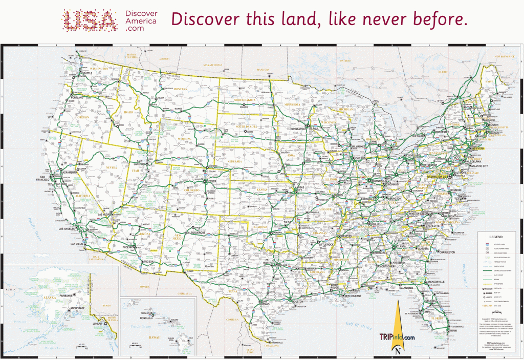


Printable Map Of Usa With Major Highways US Maps Cities And Interstate Save United States Highway Pdf Valid Free Road The Roads Intended For At In Justinhubbard Me New System MUWNH Best Atlases May 2026 51IM38SB9FL SL500 51IM38SB9FL SL500 How U S Was Created Gettyimages 153677569 D929E5F7B9384C72A7D43D0B9F526C62 153677569 D929E5F7B9384C72A7D43D0B9F526C62 All ERNKC EA8A3B67A1F2E53E8849C6F17C9DCBD2 World Explained EYZA Crawler Atlas 2026 2027 Large Scale Complete Cms Visual 4990217 1779862944000 P 3cdf614d72 4990217 1779862944000 3cdf614d72 Amazon Com 2026 71rf0 AX6ML SL1500 71rf0 AX6ML SL1500.


Map Of The U S Interstate Highway System Act 9239657 List Highways US Atlas USA Free 5A Infographic As A Transit Major.