Ever wondered how goods move across our vast nation or dreamt of a scenic train journey? A comprehensive map of US railways unveils the intricate network crisscrossing America, highlighting major freight lines and passenger routes. Understanding this vital infrastructure provides crucial insights for logistics professionals, history enthusiasts, and travelers alike. From the bustling corridors of the Northeast to the expansive Western territories, the map of US railways details the backbone of American commerce and connectivity. This essential navigational tool helps comprehend the scope and scale of railroad operations, influencing economic development and shaping regional accessibility. Explore the fascinating world of train travel and freight movement across the United States. This detailed overview covers key aspects and future trends.
How many miles of railway are in the US?
The United States boasts an extensive railway network, with approximately 140,000 miles of track in operation. This vast system includes both freight and passenger lines, connecting communities and industries nationwide. It represents a critical part of America's transportation infrastructure, essential for economic activity and trade across the continent.
Who owns the US railway system?
The majority of the US railway system is privately owned and operated by major freight railroads, known as Class I railroads. Amtrak, the national passenger rail corporation, operates over tracks primarily owned by these freight companies. This unique ownership structure influences how railway services are developed and maintained across the country.
What are the major US railway companies?
The primary Class I freight railway companies in the United States include BNSF Railway, Union Pacific Railroad, CSX Transportation, and Norfolk Southern Railway. These carriers manage vast networks, transporting commodities and goods across significant distances. They form the backbone of American freight logistics, facilitating national and international commerce.
Can you travel by train across the US?
Yes, you can absolutely travel by train across the US, primarily through Amtrak's long-distance routes. Popular cross-country journeys like the California Zephyr or the Empire Builder offer unique travel experiences. While not as extensive as the freight network, passenger rail provides connections to many major cities and scenic regions nationwide.
What is the oldest railway in the US?
The oldest continuously operating common carrier railroad in the United States is generally considered to be the Baltimore and Ohio B&O Railroad, which began operations in 1830. Its early lines played a crucial role in connecting inland agricultural areas to port cities. The B&O significantly shaped early American transportation history and economic development.
Are US railways privately owned?
Indeed, most US railways are privately owned. This distinguishes the American system from many European and Asian counterparts, which often have state-owned railways. Major freight carriers hold and maintain the vast majority of tracks and infrastructure. Amtrak leases access to these private tracks for its passenger services, creating a cooperative model.
The map of US railways illustrates the vast, interconnected network of tracks essential for transporting goods and people across the United States. This crucial infrastructure, primarily privately owned and operated, has evolved significantly since the 19th century. Today, it underpins national commerce, connecting major ports and industrial centers. Understanding this map is vital for logistics, economic planning, and appreciating America's development. It provides a visual guide to where trains go and how our nation moves.
The Undeniable Importance of the Map of US Railways
Delving into a map of US railways offers a fascinating look at America's transportation lifeline. These maps reveal more than just lines on paper; they show the arteries of commerce. From agricultural products to manufactured goods, freight trains carry immense volumes daily. This system supports countless industries across every state. The intricate network displayed on a map of US railways truly highlights its national significance.
Key Players and Networks on the Map of US Railways
North America's railway landscape is dominated by a few major Class I freight railroads. These giants operate extensive networks, covering vast distances across the nation. Companies like BNSF Railway, Union Pacific, CSX Transportation, and Norfolk Southern are critical. They move materials and products efficiently, connecting producers to consumers nationwide. Each player is a vital part of the comprehensive map of US railways.
Passenger Rail Travel: An Overview on the Map of US Railways
While freight dominates, passenger rail, primarily through Amtrak, connects many major cities. Amtrak's routes crisscross the country, offering scenic and often relaxing travel alternatives. A map of US railways dedicated to passenger service showcases these routes. It highlights popular corridors like the Northeast Regional and long-distance journeys such as the California Zephyr. Passenger rail provides a unique travel experience.
The Economic Power of Freight on the Map of US Railways
Freight rail in the US is a powerful economic engine, moving immense tonnage efficiently. It significantly reduces highway congestion and fuel consumption compared to trucking. The detailed map of US railways underscores its role in global supply chains. Ports rely heavily on this network to distribute imported goods rapidly. This efficiency keeps prices lower and industries moving forward.
Evolution and Future of the Map of US Railways
The map of US railways has undergone dramatic changes since the transcontinental railroad's completion. Early expansion connected a growing nation, facilitating westward migration and industrial growth. Today, investment focuses on modernizing infrastructure and adopting advanced technologies. This includes positive train control and enhanced automation. The future aims for even greater efficiency and safety across the network.
What Others Are Asking?
How many miles of railway are in the US?
The United States boasts an extensive railway network, with approximately 140,000 miles of track in operation. This vast system includes both freight and passenger lines, connecting communities and industries nationwide. It represents a critical part of America's transportation infrastructure, essential for economic activity and trade across the continent.
Who owns the US railway system?
The majority of the US railway system is privately owned and operated by major freight railroads, known as Class I railroads. Amtrak, the national passenger rail corporation, operates over tracks primarily owned by these freight companies. This unique ownership structure influences how railway services are developed and maintained across the country.
What are the major US railway companies?
The primary Class I freight railway companies in the United States include BNSF Railway, Union Pacific Railroad, CSX Transportation, and Norfolk Southern Railway. These carriers manage vast networks, transporting commodities and goods across significant distances. They form the backbone of American freight logistics, facilitating national and international commerce.
Can you travel by train across the US?
Yes, you can absolutely travel by train across the US, primarily through Amtrak's long-distance routes. Popular cross-country journeys like the California Zephyr or the Empire Builder offer unique travel experiences. While not as extensive as the freight network, passenger rail provides connections to many major cities and scenic regions nationwide.
What is the oldest railway in the US?
The oldest continuously operating common carrier railroad in the United States is generally considered to be the Baltimore and Ohio B&O Railroad, which began operations in 1830. Its early lines played a crucial role in connecting inland agricultural areas to port cities. The B&O significantly shaped early American transportation history and economic development.
Are US railways privately owned?
Indeed, most US railways are privately owned. This distinguishes the American system from many European and Asian counterparts, which often have state-owned railways. Major freight carriers hold and maintain the vast majority of tracks and infrastructure. Amtrak leases access to these private tracks for its passenger services, creating a cooperative model.
FAQ about the Map of US Railways
What is the map of US railways?
It's a visual representation detailing the extensive network of railroad tracks across the United States. It shows routes for both freight and passenger trains, highlighting key hubs, connections, and geographical coverage. This map serves as an essential tool for logistics and travel planning.
Who uses the map of US railways?
Everyone from freight companies and logistics planners to passenger travelers and history enthusiasts utilize these maps. Businesses depend on them for supply chain optimization, while individuals plan journeys or explore historical rail lines. It provides valuable insight for many users.
Why is the map of US railways important?
The map is crucial because it illustrates the backbone of American commerce and transportation. It helps understand how goods are moved efficiently, how cities are connected, and the sheer scale of the nation's railway infrastructure. It's vital for economic planning.
How does the map of US railways benefit the economy?
By showcasing the routes, the map helps optimize freight movement, reducing costs and transit times for industries. It supports efficient distribution of goods, boosts trade, and minimizes environmental impact by shifting freight from roads to rail, which is a more fuel-efficient option.
| Category | Detail about Map of US Railways |
|---|---|
| Total Track Miles (Approx 2026) | Around 140,000 miles |
| Primary Ownership | Mostly Private (Class I Freight Railroads) |
| Major Freight Carriers | BNSF, Union Pacific, CSX, Norfolk Southern |
| Main Passenger Carrier | Amtrak |
| Economic Impact | Crucial for freight logistics, reduces road congestion |
| Historical Significance | Key to national expansion and industrialization |
| Future Trends | Modernization, PTC, increased automation |
Essential for understanding US logistics and transportation. Reveals major freight and passenger routes. Showcases critical infrastructure development. Aids in historical and geographical exploration. Highlights key hubs and connections nationwide for effective planning.

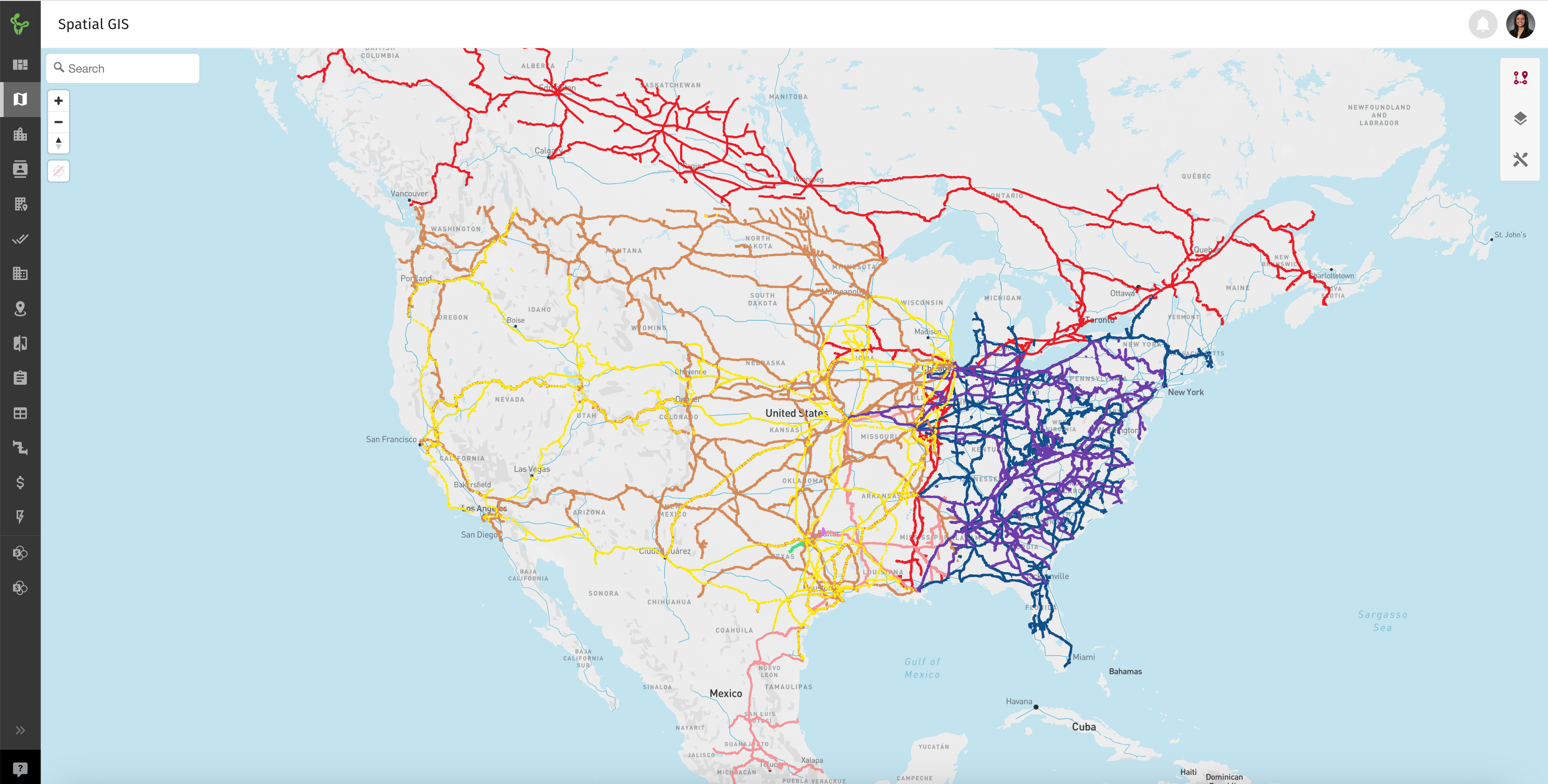


Interactive US Railroad Map Complete Rail Network Explorer January Every Rail Way In The USA . USA Rail Lines Your Guide To Exploring America N America Rail Lines Spatial GIS . High Speed Rail Vision Map Aushsr Map New 2 Syst2 . US Railroad Map Railroad Map Of US Railroad Map Of Us . Newsletter 11 1 24 2 4 Billion Awarded To Rail Projects Across The HSR Completed Federal Rail Plans Map 2024 10 31


The Best 2026 Amtrak Fall Color Trains To Explore TWK Tm1103 Amtrak Day Night 1 . US Railroad Map Railroad Map Of US Usa Railroad Map 768x475 . USA Railway Map Usa Railway Map . Rail Lines In The Us Map At Christopher Schauer Blog . USA Rail Map Major Railroads And Routes Usa Rail Map


The Rail Island Corridor Foundation US Rail Networks . Rail Network Usa Map At Lenore Schwartz Blog . Map Of Railways In USA United States Railway Map USA Railway Map 1024x791 . Amtrak S 2035 Map Has People Talking About The Future Of U S Train Proposed Amtrak Routes April 2 2021 V4 Wide S1400 C100 . Rails Across America Exploring The US Map With Railroads


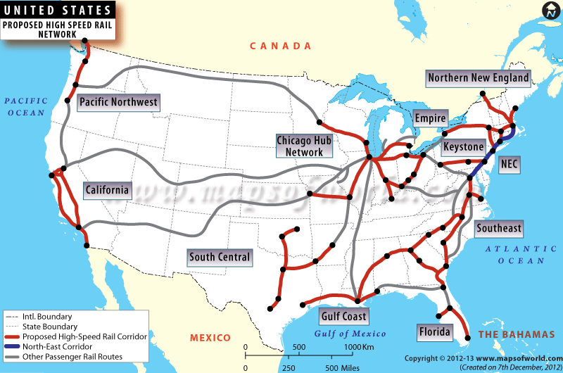


US Railroad Map Railroad Map Of US Railroad Map Of Usa . Train Travel In The USA 2025 Cross Country By Amtrak From 217 USA Train Map . USA Rail Lines Your Guide To Exploring America Us High Speed Rail Map . Train System In The Us At Margaret Bower Blog . Rail Map 76 Usa Rail Map


Aqa 2026 Gcse Timetables 2024 Election 2022 0822 1024x695 . Rail Lines In The Us Map At Christopher Schauer Blog Amtrak United States Rail Map 1024x683 . U S Rail Lines By Owner OC 3507 2480 Karta . Map Of American High Speed Rail Network Business Insider Us High Speed Rail System By 2013 02 03 . Map Of Railroad Tracks In Usa At Jonathan Landseer Blog


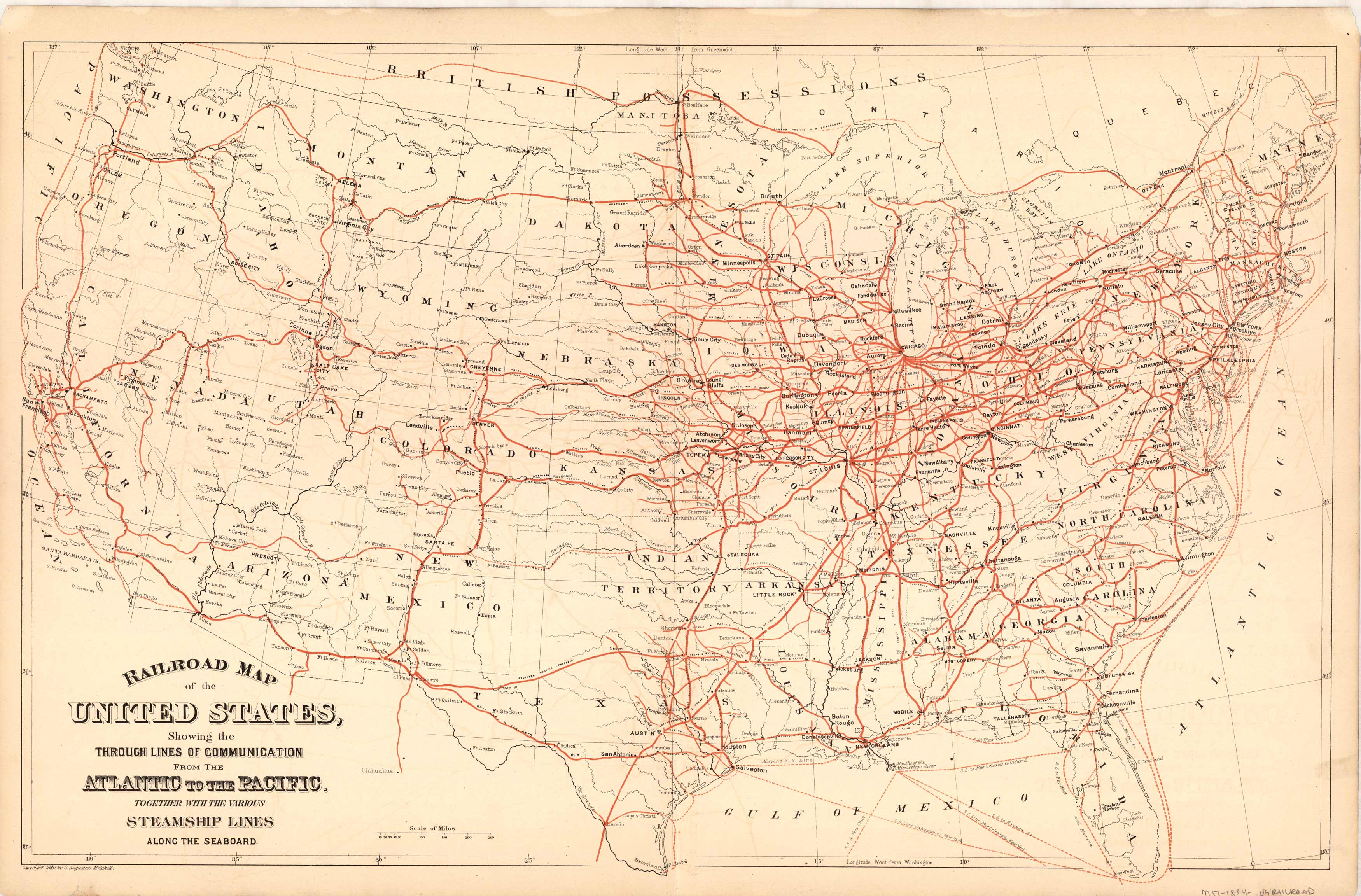

Rail Lines Map Of Us Us Freight Railroad Map . Rail Lines Map Of Us Screen Shot 2019 03 12 At 4.11.49 AM . Map Of Railway Route Open Rails Map France RMGD Map Of Union Pacific System Scaled 1 2048x1582 . Navigating The Tracks A Guide To The United States MIT 1884 USRAILROAD . American Railroads Rr Railroad Map 1900

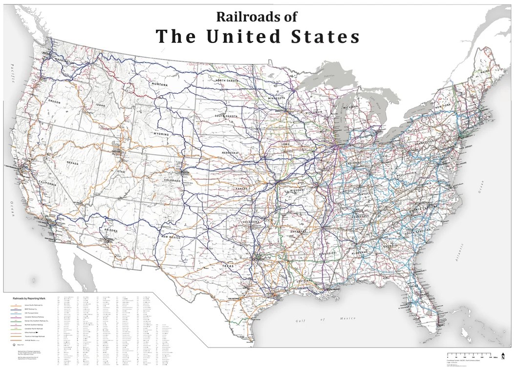


Open Railway Map Of The US R Amtrak Open Railway Map Of The Us V0 . USA Railroad Wall Map 2025 Houston Map Company USARR1 530x@2x . REM Light Rail 2026 Route Map Railway News Rolling Railwa News . Complete Guide To The Amtrak Rail Pass Grounded Life Travel Amtrak Map 1536x1104 . Plans Show Possible Routes For High Speed Rail In America 1200x0